
 We’re working to put farmers and agronomists in control.
Low cost, easy to use precision agriculture solutions via our Digital Agronomist™ platform.
From free farm mapping with NDVI to high resolution satellite imagery and variable rate technology.
Our Digital Agronomist™ tools meet the needs of agronomy service providers, and help farmers and graziers manage their crops and pastures.
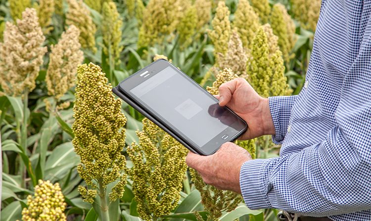
The Digital Agronomist™ Platform
The Digital Agronomist™ houses six unique tools in one cloud-based platform.
New tools are added on a regular basis, with features under constant research and development.
Click the + symbols below to read details and pricing for each tool.

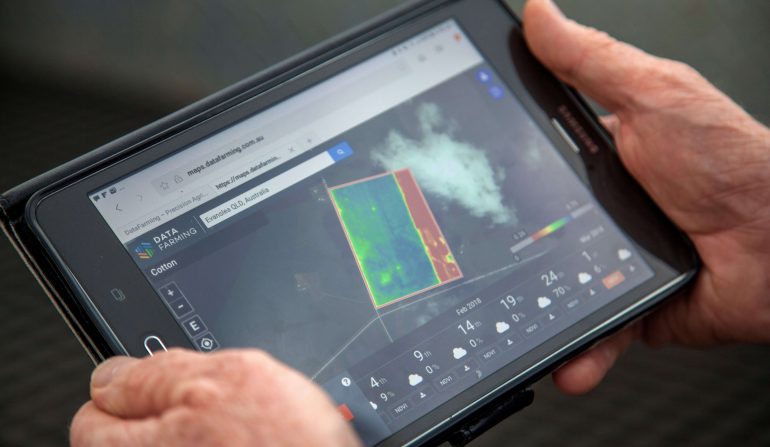
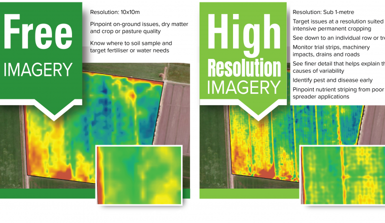
Free 10m Satellite Images

High Resolution Images

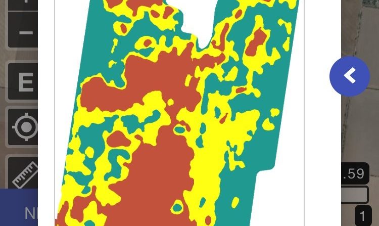
Auto-Zone

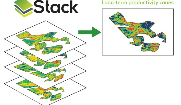
Stack

Geo-TIFF

Soil Mapping
Track crop or pasture performance anywhere in the world using our free 10x10m satellite images that show NDVI (normalised vegetation difference index) and cloud cover.
Images updated every 5 days with access back to January 2017.
To get started, simply create a free Digital Agronomist™ account and either draw your paddocks or upload a digital copy (via KML or shape files).
Use the free satellite farm maps to:
- Monitor crop and pasture health
- Pinpoint on-ground issues, dry matter and crop or pasture quality
- Save time and money knowing where to target fertiliser and water applications
- Identify problem areas prior to soil testing
- Track your location in-field while crop scouting
- Select regional view for a broader look at your local area
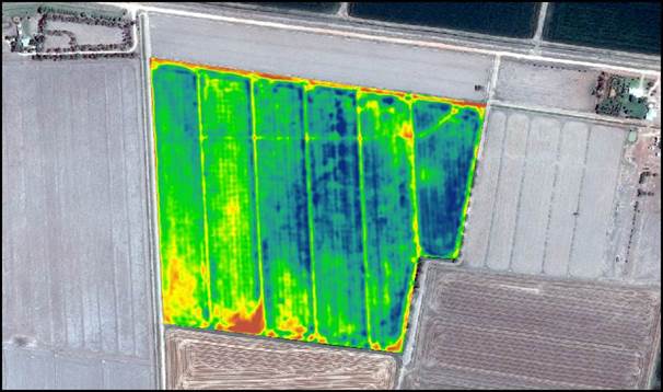
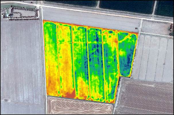
The high resolution satellite imagery tool offers an unforeseen level of detail by providing sub 1-metre or 3 metre image captures.
Ideal for monitoring in-season crop variability and performance, high resolution satellite imagery can detect issues that are difficult to spot at ground-level. Supplemented with use of our free 10m satellite maps and your usual ground-truthing, high resolution images are an extremely handy tool for helping you make decisions.
As images are captured on-demand from a satellite provider, they take 10-14 days from order to delivery. We highly recommend you plan ahead so you can access images during critical periods.
Use high resolution images to:
- Instantly target issues during critical periods at a resolution suited to intensive permanent cropping
- Pinpoint on-ground issues before crop scouting and tissue or soil testing
- Monitor and track crop vigour using NDVI (normalised vegetation difference index) and PCD (plant cell density)
- Save time and costs knowing where to soil test, and target fertiliser and water applications
- Use the imagery as part of your disease and pest monitoring
- Track your location in-field while crop scouting
- Read High Res FAQ or view this how to order video
Cost:
3 metre pixel Imagery with 5 to 10 in season captures – $AU1.50/ha +gst (discounts for areas greater than 1000ha per order and minimum order of $AU500+gst).
Sub-metre imagery (50cm-80cm pixel) with 3 to 5 in-season captures – $AU10/ha +gst (minimum order $AU375+gst).
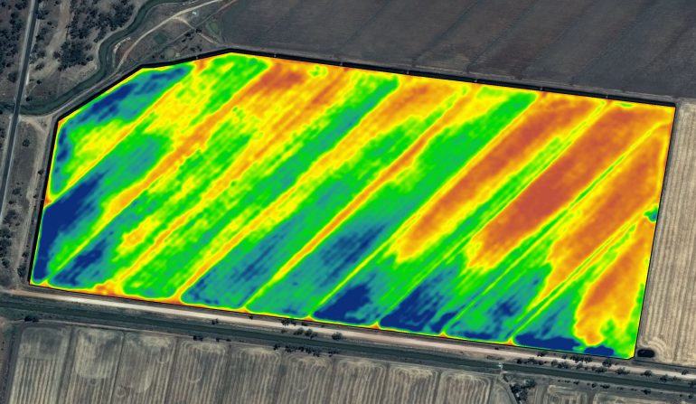
Get a stacked view of satellite imagery over multiple years to see how your paddocks have performed long-term.
By layering 5 years of imagery for one location, Stack uses NDVI maps to create a meaningful visual summary beyond what your eyes can detect.
Variable rate zone file included in the cost. Compatible with most farm machinery, including John Deere, Trimble and Case. Files directly upload into the operating system to provide for variable rate application of seed and fertiliser inputs.
Use Stack to:
- Track crop and pasture production on any paddock over multiple years
- Define soil testing and soil moisture probe locations
- Instantly access historical spatial data on new land purchases
- Choose the locations or paddocks that are important, so you can treat each one individually
- Only see what matters, with fallow/non-cropped paddocks automatically removed by the program
Cost: $0.60 per hectare
Know what to apply and where to apply it with rapid auto-zoning. Set up or upload your paddocks and easily export variable rate shape files compatible with most farm machinery systems (including John Deere, Trimble and Case).
Use Auto Zone to:
- Balance soil and crop needs in different areas
- Only apply what your crop and soil needs, potentially reducing input costs
- Quickly zone your paddocks and generate a shape file
- Upload the file into your farm machinery operating system
- Apply variable rate seed and fertiliser
Cost: $0.40 per hectare
Download raw NDVI files for upload into other farm mapping tools or programs.
Use Geo-TIFF to:
- Utilise Digital Agronomist™ insights in other platforms.
Cost: $0.20 per hectare
Soil Mapping is an autonomous soil electrical conductivity (EC) mapping solution that provides detailed information about soil structure and soil properties to enable variable rate (VR) fertiliser application.
The Soil Mapping unit easily installs behind farm equipment and vehicles and automatically logs data when moving around your paddocks. This data will later be accessed and processed using the DataFarming platform (in the near future – watch this space).
Pricing available upon request.
*Prices listed are in Australian Dollars and are exclusive of 10% Goods and Services Tax (GST).
Why the Digital Agronomist™?
 Using many agtech tools to gain farming and spatial data insights can be a long, tedious process that requires specialist knowledge.
Created by 20-year precision agriculture veterans, the Digital Agronomist™ stands out in the field by providing simple, actionable insights back to farmers and agronomists.
Instead of locking you in with a subscription, each tool within the Digital Agronomist™ platform is pay per use – except our 10m satellite images which are 100% free.
No lock in contracts or monthly costs, just the premium tools you need, when you need them.